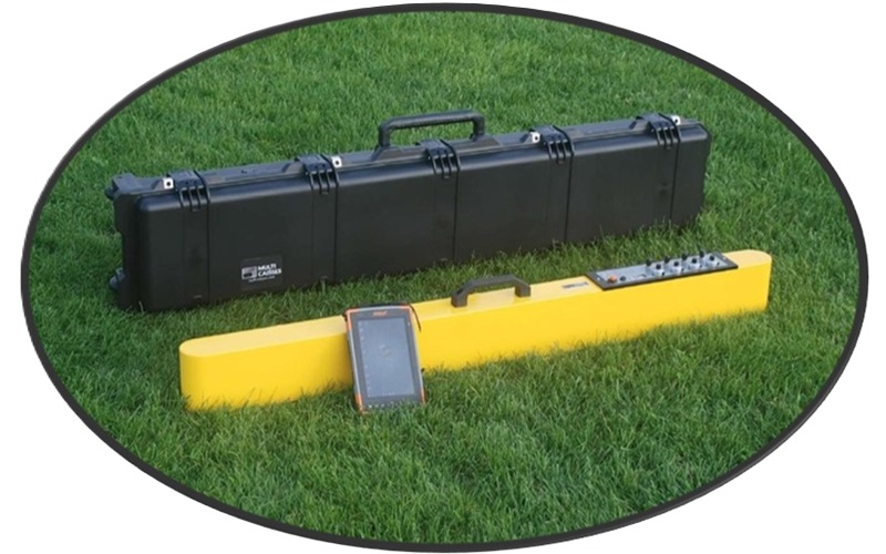
Geonics EM38-4 Soil or Ground Conductivity Meter-Buy, Sell, or Rent
EM38-4 Story: Revolutionizing Soil Analysis*
Like the EM38-MK2 industry workhorse, the Geonics EM38-4 is a sophisticated instrument designed for measuring the electromagnetic properties of the ground. It is capable of providing measurements in both quad-phase (conductivity) and in-phase (magnetic susceptibility) components across four distinct coil separations yielding responses from seven depths of investigation. This capability makes it a versatile tool for a variety of applications including agricultural uses, mapping soils and geologic conditions, environmental studies, and archaeological exploration.
Manufactured by Geonics Ltd., based in Mississauga, Ontario, Canada, the EM38-4 represents an advancement in ground conductivity meters. The device is known for its ability to offer detailed insights into the subsurface properties, which can be crucial for various geophysical surveys. The EM38-4 model specifically includes enhancements over previous models such as the inclusion of 4 intercoil spacings (1 meter, 0.88 meter, 0.75 meter, and 0.5 meter) that allow for more precise measurements at different depths using two coil orientations (vertical and horizontal dipole.) In terms of technical specifications, the Geonics EM38-4 provides a range of exploration depths from approximately 0.38m or 1.2ft up to 1.5 meters or 5ft for conductivity or in-phase geophysical survey measurements.
EM38-4 Exploration Depth Chart
| EM38-4 | Coil #1 (0.50m) | Coil #2 (0.75m) | Coil #3 (0.88m) | Coil #4 (1.0m) |
| Dipole Mode | ||||
| Horizontal | 0.38m | 0.56m | 0.67m | 0.75m |
| Vertical | 0.75m | 1.13m | 1.32m | 1.5m |
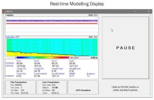
Moreover, the Geonics EM38 series, including the EM38-4, is supported by specialized software for data acquisition and analysis, enhancing its utility for professional applications. Information available from four receiver coils supports a better understanding of the soil profile through inverse modelling of the profile data both in real-time and during data processing. Two-layer modelling of the profile can be performed with the Geonics 2 Layer Real-time and Post Processing Inversion Software or EM4Soil-G Inversion Software. In addition, expanded and further inverse modelling is supported by third party software available at purchase.
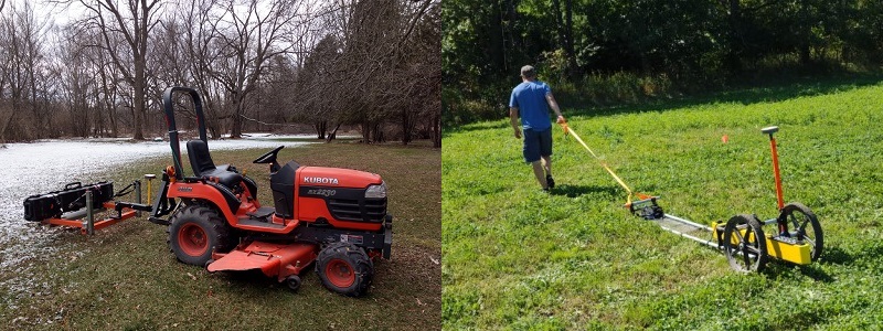
Collecting quality data with the EM38-4 has never been easier. An optional, collapsible calibration stand allows the user to complete a semi-automated calibration process without the requirement of iterative adjustments. The EM38-4 possesses the ability to connect to a data logger via Bluetooth technology to prevent frustrating cable problems. It also allows the user to view the data at a distance such as when pulling the EM38-4 with a vehicle, tractor, UTV, etc. A “Hitch-Mount Carrier” can be purchase for towing the EM38-4; this is especially useful for large surveys. A lightweight, external rechargeable battery with multiple charging inputs allows the professional in the field to collect data knowing without worrying about power.
Continuous data collection can be achieved through different deployment options such as walking, towing, and vehicle hitch mounting.
For those requiring the EM38 for specific projects, rental options are available, often including additional tools like GPS and data logging devices to ensure the most accurate data collection possible. If you’re interested in renting visit: www.geophysicalrentalequipment.com
EM38-4 Technical Specifications Chart
| Displayed Quantity: | Apparent conductivity in millisiemens per meter (mS/m) at each coil separation. Two-layer apparent conductivity model in real-time. In-phase response in parts per thousand (ppt) of secondary to primary magnetic field at each coil separation. | Operating Frequency: | 14.5 kHz |
| Intercoil Spacing: | 0.5, 0.75, 0.88, and 1 m | Data Communication: | RS-232, Bluetooth, USB |
| Conductivity Range: | 0 to 1,000 mS/m, all separations | Temperature range: | -40° to +50° C |
| Inphase Range: | +/- 28 ppt for 1 m separation +/- 22 ppt for 0.88 m separation +/- 16 ppt for 0.75 m separation +/- 7 ppt for 0.05 m separation | Power Source External: | 12 VDC Rechargeable battery |
| Measurement Precision: | +/- 0.1% of full scale | Operating Weight and Dimensions: | 9kg; 133 x 17 x 8 cm |
| Measurement Accuracy: | +/- 5% at 30 mS/m | Shipping Weight and Dimensions: | 20kg; 14- 25 x 15 cm |
| Noise Level: | +/- 0.5 mS/m (Conductivity) at 1 m separation +/- 0.02 pp (In-phase) at 1 m separation |
Geonics EM38-4 Flyer and Manuals:
The availability of software manuals and downloads from Geonics’s official website indicates the company’s commitment to providing ongoing support for its instruments, ensuring users can fully leverage the capabilities of their equipment.
How do soil scientists use apparent conductivity and magnetic susceptibility?
Soil scientists utilize an EM38-4 to measure electrical apparent conductivity and magnetic susceptibility as key indicators to understand and evaluate the physical and chemical properties of materials, often soil. Non-invasive geophysical measurements such as provided by Geonics EM38-4 offer insights into soil’s condition, variability, and composition without altering its state.
Apparent conductivity is often used by scientists to assess soil salinity, moisture content, and texture. Since electrical conductivity is influenced by the presence of water and soluble salts, apparent conductivity provides valuable information about the soil’s water-holding capacity and fertility levels. For instance, higher apparent conductivity values may indicate saline soils or areas with high moisture content, which are critical factors for plant growth and crop productivity. Apparent magnetic susceptibility, on the other hand, helps in identifying variations in soil mineralogy and texture. It measures the soil’s response to an applied magnetic field, which can be influenced by the concentration of magnetic minerals such as magnetite. This parameter is particularly useful in detecting changes in soil formation processes, pollution levels, and the presence of anthropogenic materials.
Agriculture
In precision agriculture, apparent conductivity and magnetic susceptibility measurements from an EM38-4 are integral for creating detailed soil maps that guide variable rate application (VRA) of nutrients and irrigation. By understanding the spatial variability of soil properties, farmers can optimize inputs to match the specific needs of different zones within a field, enhancing crop yield while minimizing environmental impact.
Understanding the spatial variability of soil properties can significantly benefit a farmer in enhancing crop production. Here are a few examples of how this knowledge can be utilized.
Precision Farming
By understanding the spatial variability of soil properties, farmers can implement precision farming techniques. This involves tailoring specific inputs such as water, fertilizers, and pesticides to the unique needs of different areas within a single field. As a result, resources are used more efficiently, leading to improved crop yields and reduced environmental impact.
Targeted Soil Amendments
Knowledge of spatial variability allows farmers to apply soil amendments, such as lime or organic matter, precisely where they are needed. This targeted approach optimizes soil fertility and pH levels, fostering healthier plant growth and maximizing the effectiveness of inputs.
Irrigation Management
Farmers can use spatial variability data to customize irrigation practices based on soil moisture content across different areas of the field. This helps prevent over watering or under watering, ensuring that crops receive the optimal amount of water for their specific requirements.
Crop Selection and Management
Understanding soil variability enables farmers to make informed decisions about which crops are best suited for different parts of their fields. This knowledge can also guide planting density and row orientation to maximize the use of available resources and promote uniform crop growth.
Risk Mitigation
Farmers can use spatial variability information to identify areas within their fields that are more prone to issues such as erosion, water logging, or nutrient leaching. With this knowledge, they can implement targeted measures to mitigate these risks, thus safeguarding crop productivity.
Overall, the awareness of spatial variability in soil properties empowers farmers to adopt a more precise, efficient, and sustainable approach to crop production, ultimately leading to improved yields and resource utilization.
Anthropogenic materials
The EM38-4’s ability to measure apparent magnetic susceptibility is valuable for detecting anthropogenic materials. Anthropogenic materials refer to substances, wastes, or pollutants that are produced by human activities such as industrial processes, agriculture, transportation, and urban development. These materials can have significant impacts on farmers and agricultural practices. Below are some of the ways anthropogenic materials affect farming:
Impact on Soil Health
The conscious or inadvertent deposition of man-made materials from industry, agriculture, or urban wastes poses a threat to soil health. This can lead to changes in soil composition and negatively affect the fertility and productivity of agricultural land.
Contaminant Exposure
Exposure to agriculturally derived contaminant mixtures has the potential to alter habitat quality and negatively affect fish and other aquatic life. This can impact farming practices, especially in areas where water sources are contaminated by foreign materials.
Land Use and Land Cover Changes
Unwanted factors, including the deposition of materials from human activities, have an important impact on land use and land cover changes. This can directly affect the available land for farming and the suitability of the land for different agricultural activities.
These examples highlight the complex and far-reaching effects of anthropogenic materials on agricultural systems, emphasizing the need for sustainable and environmentally conscious farming practices.
Wetland Restoration
Research has demonstrated the effectiveness of using apparent conductivity and magnetic susceptibility measurements such as those from an EM38-4 in estimating soil properties distribution in restored wetlands. These measurements can predict soil organic matter content and soil moisture content with reasonable accuracy. This capability is essential for monitoring wetland restoration efforts, aiding scientists and managers in assessing the success of their interventions and making informed decisions to improve wetland physiochemical properties.

Ground conductivity and magnetic susceptibility are instrumental in wetland restoration processes, playing key roles in characterizing soil properties and guiding restoration efforts. Here’s how they are utilized:
Soil Property Mapping
Ground conductivity and magnetic susceptibility measurements provide valuable insights into the spatial distribution of soil properties within a wetland area. This information helps in creating detailed maps of soil characteristics, aiding in the identification of zones with specific soil conditions.
Wetland Delineation
These measurements can assist in delineating different zones within a wetland, such as transitional zones between upland and wetland areas. By detecting variations in ground conductivity and magnetic susceptibility, practitioners can define boundaries and understand the composition of different zones for targeted restoration strategies.
Analyzing Peat Deposits
Electromagnetic instruments that measure ground conductivity and magnetic susceptibility are used to analyze peat deposits within wetlands. The low electrical conductivity of peat makes it well-suited for analysis using these methods, aiding in understanding wetland stratigraphy and informing restoration efforts.
Monitoring Restoration Progress
Ground conductivity and magnetic susceptibility measurements can be used as monitoring tools to assess the effectiveness of wetland restoration activities. Changes in these measurements over time can indicate improvements in soil properties and overall ecosystem health.
Overall, the use of ground conductivity and magnetic susceptibility is integral to the scientific understanding of wetland ecosystems and is essential for implementing effective restoration practices.
Environmental Surveys
Soil conductivity readings and magnetic susceptibility results from instruments such as the EM38-4 serve as crucial parameters for scientists conducting environmental surveys, offering valuable insights into soil properties, environmental conditions, and geological processes. Here’s how they are utilized in environmental surveys:
Pedoenvironmental Indicators
Soil magnetic susceptibility is used as a pedoenvironmental indicator, providing information about mineralogy, pedogeochemical processes, and environmental conditions, allowing scientists to assess the impact of these factors on the soil and surrounding ecosystem.
Discriminating Soil Grain Sizes
EM38-4 measurements, more or less, respond to soil grain size, which is a crucial step in soil analysis. By distinguishing between different grain sizes, this process helps in understanding the composition and structure of the soil. It plays a significant role in the comprehensive characterization of soil properties and materials, contributing to a deeper insight into soil behavior and quality assessments.
Relationship with Soil Moisture
Scientists consider the relationship between soil moisture and magnetic susceptibility measurements, understanding variations in soil conductivity due to changes in soil moisture content, which impacts the interpretation of these measurements in environmental surveys.
Mineralogy and Concentration Analysis
Soil magnetic susceptibility, a measure of a soil’s ability to become magnetized, offers valuable information about soil mineralogy, concentration of magnetic minerals, and their distribution. This information influences soil properties (e.g., texture and moisture content) providing key insights for environmental surveys and land management practices. By understanding the magnetic properties of soil, researchers and environmental professionals can gain a deeper understanding of soil formation processes and environmental conditions, contributing to informed decision-making and sustainable land use practices..
Spatial Variability and Soil Properties
The fundamental mechanism behind mapping electrical conductivity values involves measuring the ability of the soil to conduct electrical current. Variations in electrical conductivity across different soil types and conditions allow for the creation of detailed maps that reflect the spatial variability of soil properties. For instance, areas with high electrical conductivity values could indicate regions with higher moisture levels or salinity, which might be more suitable for certain crops or require specific management practices to mitigate salinity issues. On the other hand, areas with low electrical conductivity values could represent drier or less fertile soils, informing decisions regarding irrigation and fertilization.
Electrical Resistivity Survey
Electrical conductivity and resistivity are two sides of the same coin, with conductivity being the reciprocal of resistivity. This relationship means that the ability of earth materials to conduct electric current directly impacts the outcomes and interpretations of electrical resistivity surveys. The electrical conductivity of the soil or geological materials is influenced by several factors including metal content (e.g., sulfides), porosity, clay content, permeability, and moisture saturation. These factors affect how well electric currents can flow through the material.
In the context of electrical resistivity surveys, which are employed to collect subsurface measurements, understanding the electrical conductivity of the materials is crucial. High conductivity in the soil or rock indicates a lower resistivity, suggesting the presence of materials or conditions (such as high metal content or moisture) that facilitate the flow of electric current. Conversely, low conductivity, indicating higher resistivity, suggests the presence of materials that impede the flow of electric current, such as dry, compact soils or rocks with low metal content.
This intrinsic relationship between conductivity and resistivity is fundamental in interpreting resistivity survey data. For instance, areas with high conductivity might be indicative of groundwater contamination by metals or increased porosity, while areas with low conductivity might point to compact bedrock or dry conditions. Thus, the impact of electrical conductivity on resistivity surveys is significant, as it directly influences the detection of subsurface features, mapping of groundwater sources, identification of contamination, and even archaeological investigations.
Archaeological Surveys
Archaeologists utilize ground conductivity and magnetic susceptibility measurements in a variety of ways to gain insights into subsurface features and environmental conditions. Here’s how they use these measurements.
Identification of Archaeological Features
Ground conductivity measurements are employed to identify subsurface conductive features, such as archaeological remains, by assessing the ease with which electrical currents pass through the ground. This method helps in mapping buried structures, potential archaeological sites, and cultural artifacts.
Mapping Changes in Terrain Susceptibility
Magnetic susceptibility measurements aid archaeologists in mapping changes in terrain susceptibility, providing valuable data for identifying areas of interest for further investigation and excavation.
Detection of Subsurface Anomalies
The simultaneous measurement of both electromagnetic conductivity and magnetic susceptibility using EMI instruments enables archaeologists to detect subsurface anomalies associated with archaeological features, leading to the delineation of potential excavation areas.
Environmental Context for Archaeological Sites
These measurements offer insights into the environmental context of archaeological sites by providing information about soil properties, mineralogy, and the presence of subsurface materials, aiding in the interpretation of past human activities and settlement patterns.
Complementing Geophysical Survey Methods
Ground conductivity and magnetic susceptibility measurements complement other geophysical survey methods, such as magnetometry, electrical resistance, and ground-penetrating radar, enhancing the overall understanding of subsurface features and archaeological landscapes.
Geophysical Equipment Rentals EM38-4 Review
The EM38-4 by Geonics Ltd. represents an impressive leap forward in the field of near surface geophysical instruments, setting a new standard for efficiency and reliability in measuring soil or ground electrical conductivity. This instrument, with its state-of-the-art design and manufacturing, epitomizes the high-quality craftsmanship that Geonics is renowned for over sixty years. Its capability to provide real-time mapping of soil conductivity not only streamlines various research and agricultural practices but also offers a level of precision that is unmatched by any other equipment currently available on the market. The introduction of the EM38-4 marks a significant advancement in our ability to understand and manage the complex interplay of factors that influence soil properties, making it an invaluable tool for scientists and agronomists alike.
Moreover, the EM38-4’s robustness and ease of use underscores its potential to transform fieldwork across multiple disciplines. Whether for detailed soil analysis in agriculture, environmental monitoring, or even archaeological surveys, the EM38-4 delivers consistent and accurate data that can be relied upon for making informed decisions. Its versatility and depth of information cater to a wide range of applications, further demonstrating Geonics’ commitment to supporting scientific and practical endeavors with top-tier technology. The EM38-4 is not just a testament to the company’s legacy of innovation but also a beacon for future developments in geophysical instrumentation, promising to work for years even under rigorous daily use.
* This web page serves as an overview of one of the latest innovations from Geonics. We strive to present the most accurate and up-to-date information available to us; however, please be aware that some details may not be entirely accurate. Should there be any inaccuracies or updates required, we kindly require anyone reading this page, as noted in the site, to inform us, and adjustments will be made accordingly.
Call us today for your free quote: (800)-272-0301